Middle Harbor Shoreline Park
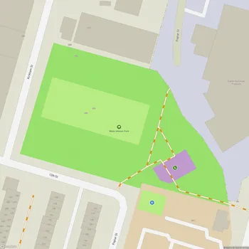
Middle Harbor Shoreline Park Map
About Middle Harbor Shoreline Park in Oakland
Middle Harbor Shoreline Park is a 38-acre public park located on the Oakland waterfront, adjacent to the Port of Oakland. The park was developed on the site of the former Oakland Naval Supply Depot, which closed in 1998. It opened to the public in 2004 after extensive redevelopment by the Port of Oakland.
The park offers expansive views of San Francisco Bay, the San Francisco skyline, and the Bay Bridge. It features nearly three miles of paved trails for walking, jogging, and cycling, including a section of the San Francisco Bay Trail. The shoreline paths meander through restored beach areas and a man-made lagoon created during the park's development.
A key feature is the Chappell R. Hayes Memorial Observation Tower, which provides panoramic views of the bay and port operations. Visitors can use free viewing binoculars at the tower and other vantage points to observe marine traffic and port activities. The park also includes an amphitheater overlooking the bay where live performances are sometimes held.
Middle Harbor Shoreline Park serves as both a recreational area and an educational site. Interpretive signs throughout the park provide information on the area's history, from its use by Native Americans to its time as a naval base. The park offers opportunities for birdwatching, with various shorebirds frequenting the restored beach areas and lagoon.
The park's location within an active port provides a unique opportunity to observe maritime operations up close. Visitors can watch massive container ships being loaded and unloaded by towering cranes at the adjacent Hanjin Terminal. This industrial backdrop contrasts with the park's natural elements, creating a distinctive urban shoreline experience.