Martha McLean-Anza Narrows Park
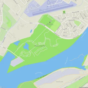
Martha McLean-Anza Narrows Park Map
About Martha McLean-Anza Narrows Park in Riverside
Martha McLean-Anza Narrows Park is a 40-acre regional park located along the Santa Ana River in Riverside, California, United States. The park is operated by the City of Riverside Parks, Recreation and Community Services Department and serves as a popular recreational destination for locals and visitors alike.
The park's name honors Martha McLean, an activist who worked alongside Ruth Anderson to prevent the channelization of the Santa Ana River proposed by the US Army Corps of Engineers in the 1960s. Additionally, the "Anza Narrows" part of the name refers to the historic crossing point where the Juan Bautista de Anza Expedition traversed the river in 1774 and 1776. A marker in the park commemorates this crossing, which is part of the Juan Bautista de Anza National Historic Trail stretching across Southern California.
Situated atop a shady bluff, Martha McLean-Anza Narrows Park offers sweeping views of the Santa Ana River. The landscape features a mix of shaded picnic areas and open turf, terminating at the bluffs that drop to the river. This picturesque setting provides an ideal environment for various outdoor activities and nature appreciation.
The park plays a significant role in local conservation efforts. Inland Empire Waterkeeper, a nonprofit organization dedicated to preserving local water quality, has adopted the park in partnership with the City of Riverside. They conduct regular volunteer-powered trash cleanups, removing debris from the riverbed and its surroundings to protect the Santa Ana River.