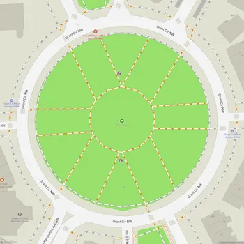
Sherman Circle
Sherman Circle Map
About Sherman Circle in Washington
Sherman Circle Park is an urban park and traffic circle located in the Petworth neighborhood of Northwest Washington, D.C. The park sits at the intersection of Illinois Avenue, Kansas Avenue, 7th Street, and Crittenden Street NW. Named after Civil War general William Tecumseh Sherman, the park is administered by the National Park Service as part of its Rock Creek Park unit.
The circular park covers approximately 2.3 acres and is surrounded by a ring road. It features a grassy central area with mature trees, providing a green space in the midst of the residential neighborhood. The park's layout includes concrete walkways that allow pedestrians to traverse the circle and access the central green space.
Sherman Circle Park, along with four surrounding triangular parks, was first documented in 1889 as part of the original plat of Petworth. However, it wasn't officially established until 1923. The park's design, created by landscape architect Irving W. Payne, aimed to reinforce the interconnectedness of the individual sites and their connections to the surrounding neighborhood.
Over the years, the park has undergone various improvements. In 1926, the circle was graded and seeded. Sidewalks were added in 1929, enhancing accessibility for local residents. More recently, in 2012, 21 pedestrian lamps were installed to improve lighting and safety in the area.
The park serves as a focal point for the community, offering a tranquil green space for relaxation and enjoyment. It provides a pleasant environment for walking, jogging, or simply sitting and appreciating the urban greenery.