Roosevelt Park
Roosevelt Park Map
About Roosevelt Park in Albuquerque
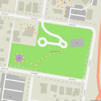
Roosevelt Park is a historic 14-acre park located in Albuquerque, New Mexico, situated south of Coal Avenue between Spruce and Maple Streets. Established between 1933 and 1935, the park was created as part of President Franklin D. Roosevelt's New Deal programs, transforming a sandy arroyo filled with garbage into a lush, green landscape.
The park's terrain consists of a series of irregular hollows, with a vertical relief of about 50 feet between the lowest and highest points. Much of the park sits below the level of the surrounding streets. The northern part is bounded by city streets, while the southern part is surrounded by a paved drive that is no longer open to traffic.
Roosevelt Park's main canopy is formed by mature Siberian elm trees, some reaching heights of up to 80 feet. Other vegetation includes juniper, blue spruce, and catalpa trees, as well as various bushes scattered throughout the park. In total, over 2,250 trees and shrubs were planted during its initial development.
The park's design, described as "Frontier Pastoral," was created by local landscape architect Clarence Edmund "Bud" Hollied. It features rolling green hillsides, meandering paths, and stone terracing. The park also contains Works Project Administration stonework in the retaining walls and picnic area abutments.
Roosevelt Park is recognized for its historical and cultural significance. It is listed on the New Mexico State Register of Cultural Properties and the National Register of Historic Places, and is designated as a protected Albuquerque Historic Landmark. The park serves as a significant example of New Deal-era landscape design in the Southwest.
In 2006-2007, the park underwent a major renovation to address safety concerns and improve its facilities. Despite its transformation over the years, Roosevelt Park remains a popular gathering place for local residents and continues to be associated with community events and activism.