Barton Creek Greenbelt
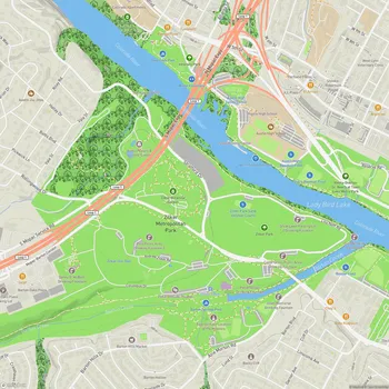
Barton Creek Greenbelt Map
About Barton Creek Greenbelt in Austin
The Barton Creek Greenbelt is a 7.25-mile stretch of public land in Austin, Texas, managed by the City of Austin's Park and Recreation Department. The greenbelt spans from Zilker Park in central Austin westward to the Lost Creek neighborhood, offering visitors a natural oasis within the urban environment.
The greenbelt is characterized by its rugged terrain, featuring limestone cliffs, dense foliage, and shallow bodies of water. Barton Creek runs through the greenbelt, creating a series of popular swimming holes that fill after periods of rainfall. The most well-known of these are Twin Falls and Sculpture Falls, which attract visitors seeking respite from the Texas heat.
The area is divided into three main sections: the Lower Greenbelt, Upper Greenbelt, and Barton Creek Wilderness Park. Each section offers unique experiences for outdoor enthusiasts. The terrain varies from flat, easily accessible trails near Zilker Park to more challenging paths and elevation changes further west.
Barton Creek Greenbelt is renowned for its diverse recreational opportunities. It's a favorite destination for hikers, mountain bikers, rock climbers, and nature lovers. The limestone cliffs provide numerous spots for rock climbing and bouldering, while the extensive trail system caters to hikers and runners of all skill levels.
The greenbelt plays a crucial role in Austin's ecosystem, serving as a habitat for various plant and animal species, including some endangered ones. It also acts as a natural filter for the water that feeds into Barton Springs Pool, a popular spring-fed swimming area in Zilker Park.
Access to the greenbelt is available through multiple entry points along its length, with the main access points including the Zilker Park entrance, Spyglass Drive, Loop 360, and the Trail's End access near Camp Craft Road. Visitors should note that water levels in the creek can vary significantly depending on recent rainfall, and it's advisable to check conditions before planning water activities.