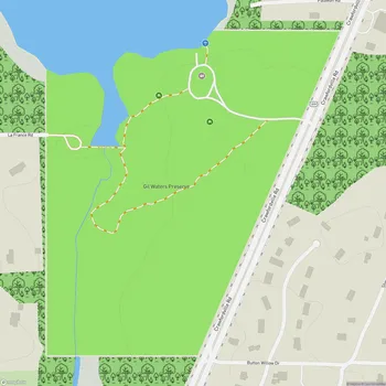
Leon Sinks Geological Area
Leon Sinks Geological Area Map
About Leon Sinks Geological Area in Tallahassee
Leon Sinks Geological Area is a unique natural site located in the Apalachicola National Forest, just south of Tallahassee, Florida. This area showcases the distinctive karst topography of the region, characterized by limestone bedrock that has been eroded over time by water, creating an array of geological features.
The park covers approximately 5 miles of trails, leading visitors through a landscape dotted with sinkholes, both wet and dry. These sinkholes vary in size and depth, with some filled with aquamarine water, offering a striking visual contrast to the surrounding forest. The most notable of these is Big Dismal Sink, which is the largest and deepest sinkhole in the area.
Visitors to Leon Sinks can observe a variety of geological phenomena, including a disappearing stream and a natural bridge. The area is part of an extensive underwater cave system that connects to Wakulla Springs, forming one of the largest known underwater cave systems in the world. While cave diving is prohibited for safety reasons, the surface features provide ample opportunity for geological study and appreciation.
The park's ecosystem supports a diverse array of plant and animal life. The trails wind through longleaf pine forests, beech-magnolia forests, and cypress swamps. Wildlife in the area includes gopher tortoises, white-tailed deer, various bird species, and occasionally black bears.
Educational signage along the trails provides information about the geological processes that formed the sinkholes and the local ecology. The area serves as an outdoor classroom for those interested in karst landscapes and the unique ecosystems they support.