Mount Tabor Park
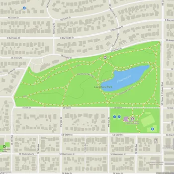
Mount Tabor Park Map
About Mount Tabor Park in Portland
Mt. Tabor Park is a 196-acre public park located in Southeast Portland, Oregon. The park is situated on an extinct volcanic cinder cone, one of several volcanic buttes in the Boring Lava Field. Rising to an elevation of 636 feet, Mt. Tabor offers panoramic views of Portland and the surrounding area, including Mount Hood on clear days.
The park dates back to 1894 when the city began building reservoirs on the site. In 1909, the city acquired additional land to create a public park. Landscape architect John C. Olmsted developed the initial design for the park, which was then refined by Portland Parks Superintendent Emanuel Tillman Mische. The design incorporated long flights of stairs, gently curving parkways, numerous walking trails, and showcased native plants.
Mt. Tabor Park features a mix of forested areas and open spaces. The park contains a variety of tree species, including towering Douglas firs, and hosts diverse wildlife, particularly birds. Three historic reservoirs remain in the park, adding to its scenic and historical value. In 2004, the park and its reservoirs were added to the National Register of Historic Places.
The park offers a network of hiking and walking trails, including three main loops of varying lengths. A unique feature is the park's volcanic nature, visible in exposed cinder layers near the summit. An amphitheater and a basketball court are located in what was once the volcano's caldera.
Mt. Tabor Park is a popular destination for various activities, including hiking, picnicking, and bird watching. The park hosts community events throughout the year, including an annual Adult Soapbox Derby race held each August.