Hampton Park
Hampton Park Map
About Hampton Park in Charleston
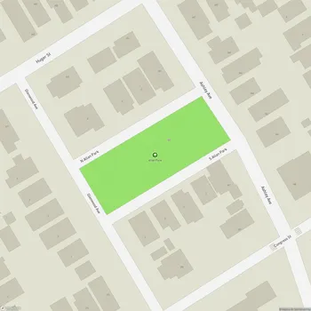
Hampton Park is the largest public park on the Charleston peninsula, occupying 60 acres of land bordered by The Citadel to the west, Hampton Park Terrace to the south, North Central to the east, and Wagener Terrace to the north. The park has a rich history dating back to the 18th century when it was part of a plantation owned by John Gibbes.
In 1835, a portion of the land was acquired by the South Carolina Jockey Club and developed into the Washington Race Course. The one-mile track hosted annual horse races that attracted thousands of spectators. During the Civil War, the site briefly served as a Union prison camp. After the war, in 1901, it became the grounds for the South Carolina Interstate and West Indian Exposition.
The City of Charleston acquired the land in 1903 and developed it into Hampton Park, named after Confederate General Wade Hampton III. The park was designed by Olmsted, Olmsted & Elliott, a renowned landscaping firm from Boston. From the 1930s to the mid-1970s, the park even housed a small zoo.
Today, Hampton Park is known for its extensive floral displays, including an old rose collection and seasonal plantings maintained by staff and volunteers. The park features a central pond with a fountain, surrounded by walking paths and landscaped gardens. A one-mile loop road, Mary Murray Drive, encircles the park, following the path of the historic racetrack.
Hampton Park serves as a popular destination for local residents and visitors alike, offering a peaceful retreat for various activities such as jogging, cycling, picnicking, and enjoying nature. The park hosts numerous events throughout the year, including weddings, family reunions, and community gatherings.